Technology rolls on

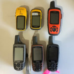
In this day and age it seems that the technology changes almost every year and for some Wildcare groups that can be a hassle. Whilst always trying to make best use of our funds, sometimes it is frustrating when the technology rolls on and leaves us behind. Friends of GIS support a few groups with […]

Christmas Locations

It’s that time of the year again – Christmas, and I hope that some of you are heading off to some of Tasmania’s Christmas locations like… Christmas Beach Christmas Cove Christmas Creek Christmas Hills or even Christmas Marsh, rock, track, village, bay or island! If you don’t know where any of these places are, then […]

Two mapping sessions before summer

Fulcrum App

Friends of GIS have just two more sessions before summer so if you are looking to get your data into our software for easy field data collection then make sure you book in for November or December. We now also have two iPads available for use by groups so its a one-stop solution! Bring out […]

Keeping track of rats and weeds

Big Green Island Bait Station Install Dates

Even wondered how you can keep track of all your weed locations or maybe how you monitor over 2,000 bait stations on a remote island? Well, come along to a Friends of GIS meeting and we can show you how Friends of Maatsuyker and Friends of Bass Strait Islands are using mobile technology to keep a […]

Digital maps and Open Data

feature_fogis

The last 3 months have seen some changes in the availability of data for those of us that like mapping and other geeky things. In December, the Tasmanian government started releasing some spatial data via an “Open Data Portal” where its possible to download GIS vector data such as the road network, rivers, streams, lakes, […]